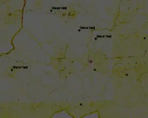
THE ORDNANCE SURVEY MAP OF 1837 INDICATES THAT IN THE LOCALITY THERE WERE GRAVEYARDS AT:-
Muchwood,
Elm Grove,
Killaconnigan,
Kildalkey,
Near KIllyon House,
Clondalee Bridge,
Clonee,
Castlerickard,
and Kilglass, Longwood,
AND A BURIAL SITE AT :- Rathcormick, Kildalkey

Fig 1 Indicates the sites of Graveyards and Burial sites on the Ordnance Survey Map of 1937 Licence No. MNE 0000112.
IN THE 1920’S ORDNANCE SURVEY MAP
The Graveyard at St Kinneths is identified
As well as the older sites at
Muchwood,
Elm Grove,
Killaconnigan,
Kildalkey,
Near KIllyon House
Clondalee Bridge,
Clonee,
Castlerickard,
Kilglass, Longwood,
The Site at Gortnakilly, Rathcormick, Kildalkey is recorded as being disused at that time.
Other sites have been consecrated since then.
It is likely that there are other sites in the locality that local people may be aware of.
MORE TO FOLLOW
